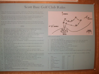
Saturday, 17 December 2011
New Zealand Christchurch Antartic Centre Last Day
Tuesday, 6 December 2011
Week 6/7 New Zealand South Island
We were a little surprised when we turned up at our hotel in Christchurch to see the front of it boarded up and reception operating from a portakabin. The first hotel we had booked had been demolished in the February 2011 earthquake. This was our new one.
1000 buildings in a 4 block area of 4000 buildings have had to be demolished.
These are typical scenes in Christchurch with some buildings boarded up, open spaces where buildings used to be and building cranes on the skyline. In the suburbs we saw many damaged walls on private houses plus there were many landslides in the hills around. The photo of Tasmin Lake below there was also a 3.5m Tsunami on the lake 150km away due to ice falling off the glaciers.
This is Mount Cook the highest mountain in New Zealand at 3754m. Twizel is a town close to Mt Cook and is known as the driest area in New Zealand. The other side of this mountain is the wettest area.
Around Mount Cook there are many glaciers and glacial valleys. This is Tasmin Lake which has several icebergs floating in it from the Tasmin glacier which runs for many km down to the Tasmin Lake. This is a very spectacular area and a very dangerous area. Many people have died trying to climb the mountains around Mount Cook and they are all remembered at the Visitor Centre at Mount Cook village.
Mrs Lockwood by one of the Moeraki Boulders just north of Dunedin. They are almost perfectly spherical.
Along the way we saw some New Zealand Fur Seal Pups some of which were only a couple of days old. This one was suckling milk in the Rookery.
In the centre of the photo is a Yellow Eyed Penguin. These are one of many species of Penguin in New Zealand which has more species of penguins than anywhere else in the world. The Yellow Eyed Penguin is endangered and nests on the cliffs above quiet beaches. In November they are hatching eggs. One parent will fish all day whilst the other stays on the nest. We also saw the much smaller Blue Penguin at the same location.
Around Te Anau there are many beech forests with beautiful ferns .
Te Anau is a small town in Fiordland
where one of the major tourist attractions is Milford Sound. This is a 120km drive each way from Te Anau and gradually goes through more and more spectacular scenery. Lakes,gorse and lupins abound at the start near Te Anau Downs.
The road then progresses into steep glacial valleys with snow topped mountains and massive waterfalls everywhere.
Milford Sound leads into the Tasmin Sea 15km away. It is surrounded by majestic peaks and glaciers. Many of the names are Welsh after the person who navigated the sound in the 1800's . Pembroke glacier, Milford Sound. Many other places in the south of the island are named after Scottish places.
Lupins were not native to New Zealand but they now grow wild all over the mountain area and make a spectacular show.
At the eastern end of the Haast Pass, Lake Wanaka and Lake Hawea provide stunning scenery surrounded by mountains.
Heading down the coast towards Haast the Southern Alps start to appear and the link between the east and west coasts finds a way through via the Haast Pass.
This is just below the Franz Josef glacier where we walked in dense rain forest with tropical type palms and foliage. The forest areas come right down from the mountains to the sea on this western coastline of the South Island.
This is the walk up to the Franz Josef glacier across the moraine filled river bed. There are many spectacular waterfalls coming down hundreds of feet along the valley. You can get a guide to take you up onto the glacier or a flight to fly over the glacier or Mount Cook which is over the mountains behind,
The ant train is all the people going up the terminal moraine with guides before going for a trek onto the glacier. Mr Lockwood took Mrs Lockwood up there but as he did not have all his climbing gear with him we stopped before going onto the ice.
The Franz Josef and Fox Glaciers are both very popular with tourists . Both areas have some good "tramping paths " around them. In NZ its called tramping not hiking or walking.
In Hokitika we visited a glow worm dell one evening just after it got dark. It was like walking in a fairy grotto with little twinkly green lights . The glow worm is not actually a worm it is either a fly or beetle type insect that
has bioluminescence. This is the ability to produce light through a chemical reaction in the body. It was an amazing sight. There are several areas and caves within New Zealand where they can be seen.
Photo courtesy Wikipedia as mine would not show up.
Apart from tourism New Zealand is heavily dependent on farming in particular sheep and cattle. As its early summer there are lots of new born calves and lambs about.
Mrs Lockwood was tempted to sit down on this chair but it was made from rock and one of several examples of artists work around the Hokitika area,
Many of the bridges across the rivers on the south island are single track for cars but this one was not only single track for cars but it was also shared as a railway track.
This is Pan Cake Rocks near Hokitika. The rock is limestone and has been built up by thin layers to form some unusual rock formations.
There are also numerous caves and blow holes within the area where the sea comes crashing through.
This is Split Apple Rock in the Abel Tasman National Park. Most of the area is only accessible by walking or boat . THere are water taxis running along the coastline to pick you up if you have done one of the many walks in the area.
Considering New Zealand is supposed to have all the birds and Australia all the "Nasties" we haven't actually seen that many birds that are different from the UK. This is a Weka which was quite friendly walking up to us. Many people mistake it for a Kiwi as it has similar colouring. Kiwis are rarely seen as they are nocturnal and live in a few remote areas. They also have numerous predators such as weasels and stoats both imported from Europe in the past to control rabbits. New Zealand now has a very strong conservation and protection policy which you will witness at customs when arriving. We had our walking shoes inspected as we had walked in forests in Australia.
This is a Pied Shag sitting on her nest. You can just about see the chicks in the nest with her.
This is Picton, the gateway to the south island if you come by ferry from Wellington on the north Island. The earthquake we felt in Wellington was centred about 20km south west from here.
The Interislander Ferry between the islands crosses the Cook Strait and then travels down the Tory Channel into Queen Charlotte Sound.
The Cook Strait is renowned for being very windy and on the day we travelled it was wet and windy. Several children were having difficulty standing up against the wind on the top deck but we stayed up there for the whole 3 hour crossing hoping to see a whale. No such luck!
Mrs Lockwood resting after a very tough climb up from the valley on the Burns Glacier Walk. The valley and walk were deserted with just the sound of the waterfalls and the occasional bird.
Many of the towns in this area are named after Scottish towns as the first settlers were Scots. This is just down the road from Glenorchy. The scenery is also simialr to the western coast of Scotland but with glaciers.
Queenstown is the hub of Otaga and Fiordland. It is a very busy little town with a great atmosphere full of tourists and back packers. It is known as the centre of adventure with many extreme activities on offer. Skydiving, parasailing, bungee jumping, gorge swinging, jet boat trips etc,etc. The beach areas on the lake were packed with people sunbathing and having a good time at 21:00 in the evening. The area is stunningly beautiful.
Coming over the Pass from Wanaka to Queenstown buildings still in use from the gold mining era of the late 1800's early 1900's are still evident. The roads in this area were only sealed with tarmac in 2000.

has bioluminescence. This is the ability to produce light through a chemical reaction in the body. It was an amazing sight. There are several areas and caves within New Zealand where they can be seen.
Photo courtesy Wikipedia as mine would not show up.
The Cook Strait is renowned for being very windy and on the day we travelled it was wet and windy. Several children were having difficulty standing up against the wind on the top deck but we stayed up there for the whole 3 hour crossing hoping to see a whale. No such luck!
Monday, 28 November 2011
Week 5 New Zealand North Island
This is Mount Taranaki on New Zealands west coast. It is a composite volcano which is currently dormant. It is also known as Mount Egmont.
One of the best walks in New Zealand the Tongiriro Crossing is here , unfortunately we did not have the time or the weather to do it.
It is also part of New Zealands major ski area on the North Island although looking at the boulder field in the ski resort it was difficult to imagine how deep the snow must get to cover them up to be able to ski.
Earthquakes, volcanoes , tsunami are all part of New Zealand life and you just have to know what to do if one occurs. All the hotels have information in their guest folders.
Aratiatia Rapids in full flow.
Black Swans are common within the area of Lake Taupo.
On the edge of town there is a large thermal area which also contains geysers the largest of which is Pohutu Geyser which erupts every half hour to a height about 30m.
People take spades to the beach and dig holes in the sand which then fill with warm water which comes up from underground springs heated along the volcanic fault line. They then sit in the warm water and relax. This can only be done at low tide.
near Whitianga on the Coromandel Peninsula.
It has many sea stacks and caves.
This is the Whitianga Area of New Zealand overlooking Mercury Bay , Lonely Beach and Cooks Beach. Mercury Bay was named by Captain Cook when he visited the area in 1769. He came to find the exact position of New Zealand in the Pacific which he did by making an observation of the planet Mercury as it moved across the skies of New Zealand in that year. He spent 10 days in the area making the observation.
This is the trig point on Shakespeare Point above Cooks Beach. The plaque commemorates Cooks acheivement of finding the exact position of New Zealand in the Pacific and mapping the New Zealand coastline throughout. It proved to be reliable for more than 150 years for Mariners.
Mercury Bay also has visting Orca Whales which chase the Stingrays into the harbour area. Unfortunately we didn't see them!!
The coastline around Whitianga is part of a volcanic fault line that runs from Taupo in Central North Island out to White Island in the Pacific. This is part of the Pacific Ring Of Fire. Faults along the main fault line have been eroded by the sea to form caves, stacks and blowholes, Tour operators in the area take boats into the caves.
The area is famous for game fishing in particular Red Snapper and Marlin. So far New Zealand is very similar to UK apart from they have a lot of ferns and palm trees and some exotic flowers. We have seen many birds similar to the UK like the sparrow, thrush , blackbirds and herons.
There are also plenty of cows and sheep.
Subscribe to:
Posts (Atom)